https://www.wonarm.com/iran-and-the-middle-east-geopolitical-power-and-natural-fortresses/
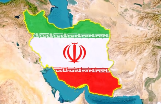
On everyday maps, Iran seems to be just an ordinary Middle Eastern country with an inconspicuous area. But the fact is just the opposite. Iran is not only important in the Middle East, but also occupies a place in the global map . Its land area, resource reserves, geographical location, and even cultural history are far larger and more complex than what you see on a flat map.
Iran’s real size: the world’s 17th largest country
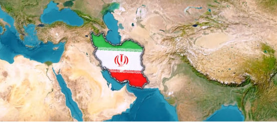
Many people think that Iran is not big, and is even about the same size as some European countries, but Iran’s actual area is 1.645 million square kilometers , ranking 17th in the world. This means that it is larger than France, Germany, and Italy combined, and closer to the U.S. state of Alaska . If Iran were “moved” onto a U.S. map, its east-west span would stretch from Washington State all the way to Texas ; if it were placed in Europe, it would almost cover the range from the UK to Greece .
Why are we so misled about its size? The answer lies in the way the map is projected.
Why do maps deceive us? The secret of Mercator projection
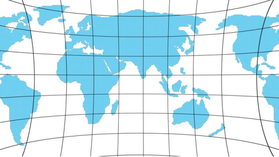
Most of the world maps we see are Mercator Projection . This projection was first used for navigation because it allows the longitude and latitude lines to remain vertical, making it easier to measure routes. But the cost is that the higher the latitude, the more exaggerated the area will be .
Countries near the equator look small : Iran, for example, is actually huge in area but appears “skinny” on the map.
Countries close to the poles are “magnified” : Greenland is the most typical example. On the map, it is larger than the African continent, but in reality, the area of Africa is more than 14 times that of Greenland!
This also explains why we feel that Alaska is “huge” on the map, while Iran seems “dispensable”. In fact, Alaska is slightly larger than Iran, but the difference is not significant.
Across the Corridor of Civilizations: Iran’s Geography and Borders
Iran is not only large in area, but also extremely important in terms of geography. It borders Afghanistan and Pakistan to the east, Iraq and Turkey to the west, Armenia, Azerbaijan and the Caspian Sea to the north, and the Persian Gulf and the Gulf of Oman to the south . This geographical structure makes Iran a hub where Central Asia, South Asia and West Asia meet . Whether it is a historical trade route or a modern energy channel, it is an important link that cannot be ignored.
This land not only has diverse terrain:
To the west are the continuous Zagros Mountains , a natural barrier and a strategic military high ground;
The north is the Caspian lowlands and plains , rich in agricultural and fishery resources;
The central and eastern parts are dominated by plateaus and deserts . The famous Dasht-Lut Desert is one of the hottest areas on earth.
Such natural conditions have shaped Iran’s diverse climate and culture, and have also determined that it has been a stage for competition between civilizations and empires throughout history.
Population and resources: the confidence of a “great power” in the Middle East
The large area is only one of the reasons . Iran’s population size cannot be ignored . According to the latest data, Iran’s population exceeds 85 million, second only to Egypt in the Middle East, and is a typical populous country. This population size means a huge labor market and domestic consumption potential . This is partly why Iran can still maintain a certain degree of self-sufficiency under the economic blockade.
More importantly, Iran has one of the largest natural gas reserves in the world and abundant oil resources . According to OPEC data, Iran’s proven crude oil reserves are among the highest in the world, and its natural gas reserves have long been ranked second in the world, second only to Russia. This makes it a key “chess piece” in the global energy market. Even under severe international sanctions, Iran is still a heavyweight in energy diplomacy.
Culture and history: more than just a “Persian” sentiment
Iran’s cultural heritage and history are equally amazing. The ancient Persian Empire once ruled across three continents and influenced the civilization process from the Mediterranean to the Indus River Basin. Even today, Persian culture is still reflected in the daily lives of Iranians:
Persian is the official language, using an ancient writing system;
Nowruz (Persian New Year) remains one of the most important national holidays;
Iran has contributed many world cultural heritages in the fields of poetry, art and architecture, such as the mosques in Isfahan and the Persian Gardens.
This makes Iran not only a geopolitical power, but also a symbol of civilizational heritage . Its influence transcends national borders and radiates throughout the Middle East and even the world.
Why do we misread Iran? The mismatch between mental maps and reality
Interestingly, many people’s impression of Iran comes more from news headlines than actual geographical knowledge. Due to the visual bias of map projection and the fact that Western public opinion has long focused on the Middle East conflict, people tend to “label” Iran and ignore the fact that it is a large country with a vast territory, rich culture and abundant resources .
This bias reminds us that maps are not only geographical tools, but also cognitive frameworks . The world we see may not be its true scale.
Summary and reflections: Iran beyond the map
Next time you look at a world map, think about this: the country that seems to be “shrinking” in your eyes may actually be bigger and more important than you think. Iran is such an example. It not only has a vast territory and resources, but also plays an important role in the global energy landscape, geopolitics and cultural exchanges.
What do you think? If you put Iran on a map of the United States, does the image of a “giant” stretching from the west coast to Texas refresh your perception? Feel free to share your views in the comments section and forward this article to let more people re-understand the true face of Iran.
https://www.wonarm.com/iran-and-the-middle-east-geopolitical-power-and-natural-fortresses/